
West Coast of Haida Gwaii

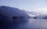
Cape St. James
As I write there is an potentially disastrous story unfolding off the west coast of Haida Gwaii. A Russian container ship, the Simushir, is drifting without power within 12 miles of the rocky shores. This has inspired me to go into my archive and show some pictures from the area. It is very close to my heart as one of the most amazing wildernesses I have every been to. I have worked on Haida Gwaii on and off since 1983, and on the west coast since the early 1990’s.
To see more of my photos from my most recent trips to Haida Gwaii follow this link.

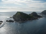
Houston Stewart Channel
The Simushir has a cargo of mining machinery and full tanks of bunker fuel and diesel as it recently departed from the Seattle area. The latest news while writing this is that she is under tow from a small Canadian Coastguard vessel – one of two tow lines has broken but they are making way to the west at 1 to 1.5 nautical miles per hour. Heavier vessels will be on the scene at 2 am and 3 am, and a large tug is expected mid-day. The weather is forecast to get worse and the wind to swing towards the shore. This is a very tenuous situation. The towing vessel is small and working at capacity. If the tow line breaks, this ship could easily run ashore and that would be it for the vessel – it won’t stand a chance in this area in a storm.
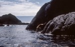
Coastal geomorphologists have classified this shoreline as the most exposed in Canada. In this area there are no anchorages, there is not even any continental shelf to speak of. Water can be several hundred metres deep within several hundred metres of shore. There is nothing growing on the rock cliffs on the outer shores for at least 50 feet above tidal level – it just gets swept off by waves in the winter, and fall, and spring. There is no overland access to much of the area. A few logging roads in some northern sounds and inlets, none in the south and none on the outer shores.
I was fortunate enough to spend a couple of months working along the shore of Gwaii Haanas park at the south end in exceptionally calm weather. It was so calm that we could run our zodiac in the gap between the kelp beds and the base of the cliffs and did so the entire length of this shore. There are a few inlets, mostly steep sided, most with a reef in their mouth and many are not even properly charted, lacking depth soundings. There are some larger bays too, but they have narrow openings and treacherous waters inside. A ship in distress really has nowhere to go. And any mess resulting from a grounding will be very hard indeed to clean up.
Frequently when working in this area we could find nowhere to get ashore for lunch – no place that you could get out of a boat within in reasonable distance and so we would tie up to the kelp for a break. That was in perfect weather with a swell of about 1/2 metre, the least we ever saw out there. Overall, a very difficult place to be in any kind of weather even in the summer.
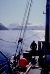
These pictures are a personal tour of places I have been on the west coast to give some sense of what it is like. If it was at all rough out, the camera stayed in its case, so some of the most difficult shores are missing from this series. I hope you like them, it has been good for me to work on these photos for the past few hours while tracking the news, it looked very dire when I started, but there seems to be room for optimism as I get ready to publish. This is a wonderful place that would suffer terribly from a ship wreck and the oil they must carry just to transit oceans.
The idea of oil tankers aground here doesn’t bear thinking. And this situation exposes the inability to get heavy tugs into the area quickly – it will have been well over a day to get one on scene. The small Coastguard vessel took many hours to get on scene from the central coast, and the bigger ones will have taken a day from the time the engines died on the Simushir. It is not far from here that some of the largest waves in the world have been recorded (105 feet) in Hecate Strait. The idea of shipping oil from the tar sands out along this coast seems insane. I hope this event ends up well, and I hope that it wakes up some of the sleepy headed politicians and tar sands supporters to the real dangers of this plan.
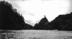
The pictures are ordered from south to north. Cape St. James is the southern tip of Haida Gwaii, just off Kunghit Island. Rennell Sound is a bit north of Skidegate Channel which separates the two largest islands, Graham and Moresby – there is much more of the west coast of Haida Gwaii north of where I have pictures from.
And, to repeat myself, to see more of my photos from my most recent trips to Haida Gwaii follow this link.

2.5 km south Mike Inlet
.
To see larger views click on any of the thumbnails below and then use the arrow keys to navigate and the escape key to return to this page.
-
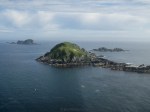
- Cape St. James
-

- Cape St. James
-
- Cape St. James
-

- Cape St. James
-

- Cape St. James
-

- Cape St. James
-

- Woodruff Bay
-

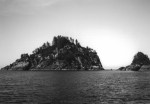
- Sgang Gwaay
-

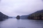
- Houston Stewart Channel
-

- Houston Stewart Channel towards Hecate Strait – Kunghit Island left, Moresby Island right
-

- Houston Stewart Channel
-
- Houston Stewart Channel
-
- Houston Stewart Channel – Kunghit Island left, Moresby Island right
-
- Houston Stewart Channel
-

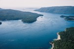
- Outflow Upper Victoria Lake
-

- Below Upper Victoria Lake
-

- Mouth Gowgaii Bay
-

- Gowgaii Bay Inner
-
- Gowgaii Bay Inner
-

- Mouth Gowgaii Bay?
-

- Puffin Cove inner
-

- Puffin Cove inner
-

- Puffin Cove
-

- Puffin Cove entrance
-
- Puffin Cove offshore
-
- 2.5 km south Mike Inlet
-
- 2.5 km south Mike Inlet
-

- South of Tasu Head
-

- 4 km SE Tasu Head
-
- 4km SE Tasu Head
-
- South of Tasu Head
-

- Peel Inlet from Moore Inlet
-
- Mitchell Inlet
-
- Peel Inlet from Moore Inlet
-

- Inskip Inlet
-
- Inskip Inlet
-

- Mitchell Inlet
-
- Mitchell Inlet
-

- Kaisun, Engelfield Bay
-

- Rennell Sound
-

- Rennell Sound
-
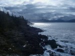
- Rennell Sound
-

- Rennell Sound
For this post I scanned some Kodachrome slides, some small black and white prints (no negs anymore) and edited files from various generations of point and shoot digital cameras, with a few recent photos from DSLR cameras.
[Edited Oct 18th morning for typos, some paragraphs moved around for clarity, no substantial changes].


Pingback: Haida Gwaii Seascapes | 52 rolls
I’m catching up on posts I didn’t get a chance to read over the weekend – so by now the fate of this container ship may well have been decided I presume. And I hope, sincerely, that it is now under a safe tow. This looks a wonderfully pristine coastline – it would be disaster if it were fouled by a grounded ship with all the horrendous consequences.
LikeLike
Hi Andy.
The container ship, under tow, reached Prince Rupert on the north coast of BC a few hours ago and is now being repaired.
The coast is fantastically pristine. In 94 we went for a whole week without seeing another vessel, and the rest of the time saw very few, though once the salmon fleet sailed by on its way to an opening to the south of us. That summer we did not once see anyone else in a small boat, kayak, or similar – it is just too difficult a place for all but the most highly experienced boat operators.
I had so many terrific wildlife experiences there, such as peregrine falcons hunting cormorants from off their cliff nests in narrow and very high surge channels, and a peregrine seeing us off from Cape St. James by flying over the top of our boat at 35 knots for several miles.
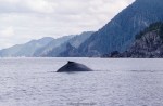
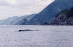
While tied to the kelp for a lunch break, sitting in a zodiac I had this feeling and looked behind me to find, just below the surface and barely more than an arms length away, the eye of a humpback whale, checking us out. When it sank into deeper water we could see its calf feeding along the kelp.
Sea lions were a routine, pretty much daily, experience, we saw albatross once, we saw orcas and had one ride on the bow wave of our charter vessel, huge numbers of white sided dolphins (hundreds or even thousands in a school). I will never forget watching two humpback whales rise totally out of the water, belly to belly, and in perfect choreography, slowly peel away from each other and splash down at the exact same moment.
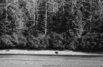
On land we saw bears frequently, and they seemed unfamiliar with people and not alarmed by us. I shared a patch of salal with one, where we both climbed onto rock pinnacles to get above the salal to see, and stared at each other from maybe 20 feet for quite a while, before I suggested it just take in the view for a bit longer while I made my way back to the boat, which it appeared to agree to. The Haida Gwaii black bears are quite different from the mainland bears – with very long legs they can stand 5 feet at the shoulders. They do a large amount of feeding in the intertidal zone; we often saw them turning over large boulders in search of edibles.
We caught halibut pretty much at will, and ling cod and other delicacies of the sea. The day before quite a few of these photos were taken was my birthday and our skipper asked what i would like for dinner. I said halibut and a few minutes later he stopped the boat and handed me a jigging line, which I dropped to the bottom, raised a bit and gave two or three pulls up before I had a 20-30lb halibut hooked. He knew the good spots!
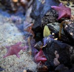
The intertidal life is amazing as well, very rich, very diverse. The shorelines are highly crenellated with many islands and inlets and rocks and so on giving a massive amount of shoreline in this area. The stretch of shoreline I was working one year was 78km NW to SE as the crow flies, but included more than 325km of actual shoreline of which only 55km could be walked in any way, the rest was vertical. And this is a very linear shoreline compared to the south east coast of the Haida Gwaii. Huge biomass, terrific diversity, and much of it sensitive and fragile, even though in such a hostile environment.
A wonderful place, that would pose the most extreme challenges for cleanup, to the extent that I suspect most of it would be left for nature to take care of. So best if we can ensure that nature not have to do our dirty work in this area.
LikeLike
Thx. I looked up “straight iron-bound shore” too in the pre-internet era. I think they meant there are no ports on the outer coast between San Francisco and Strait of Juan de Fuca and Victoria, and none at all to the north in the “graveyard of the Pacific.” At any rate a very inhospitable area where a good working engine is a necessity!
LikeLike
Yes, not to mention deliberately stationed rescue vessels capable of dealing with any sized ship including in terrible weather. The tug that did this job just happened to be on the north coast (though nearly 2 days away) – normally it is based in Washington State as a rescue tug hired by the state. There are no rescue tugs based on the BC coast north of the Salish Sea. And the Coast Guard vessel that performed over and above expectations took 16 hours to get there from the central coast area. The other coast guard vessels, one American and on Canadian took 24 and 26 hours to get to the scene. The tug took nearly two days. Just not good enough.
LikeLike
Pingback: Strait Rocks | burnt embers
“…the most exposed in Canada. In this area there are no anchorages,…” In the 1830s, the fur traders called this coast a “straight iron-bound shore.”
LikeLike
“Iron bound shore” is an interesting phrase. Looking up its meaning finds many examples of its use where the meaning is clear but no actual definitions. On the internet anyway. There must be old fashioned specialty dictionaries that include it.
LikeLike
Well, the current situation is that they have towed the ship 46km offshore but have broken three tow cables and presently are unable to get another line on the Simushir so she is drifting free again. They are still waiting for the big tug to arrive – the Simushir first lost power at 1:30am yesterday – it has been more than 37 hours and the tug still is not there. Bodes ill for future accidents in this area.
LikeLike
Of course the gorgeous photography here of this area turn “West Coast of Haida Gwaii” in an immediate favorite. The photography, however, supports the srtory and the story is one of the better stories showing why tankers in this part of the world are a big and absolute no no.
LikeLike
Hi Joseph. The lack of effective infrastructure has been exposed. The idea that in good sea conditions it takes at least 20 hours for a big tug, that just happened to be on the north coast, to get to this area, and in this case nearly 2 days in transit, is just not good enough. The wind could have been blowing onshore rather than along it and the ship would have been aground in a few hours. The coast guard vessel that started the towing has no business towing a ship this size, let alone a tanker, and it must have been a dangerous job with low margins for success. I would like to know more about that CG vessel – it seemed to originate from the Central Coast area – was it stationed in Hartley Bay or Bella Bella, or was it fortuitously en route and thus “only” 16 or so hours away? I hope there is some very public analysis of this incident – it is needed.
LikeLiked by 1 person
Holding my breath hoping dawn in BC brings good news.
LikeLike
Thanks Beth. Seems to be working out.
LikeLike
Great series – can see why you like the place and with luck it will all be ok.
David.
LikeLike
Thanks David. There were some very anxious hours here, and while the risk is not totally averted, it seems like it will be.
LikeLike
I sure hope they can forestall that disaster. I’ll be checking online, I doubt this would make it to our news services in Australia.
LikeLike
Hi Yvonne. The situation is still stable, we are optimistic now that it will end well, but it was a very close call.
LikeLiked by 1 person