Fisheye Tracks
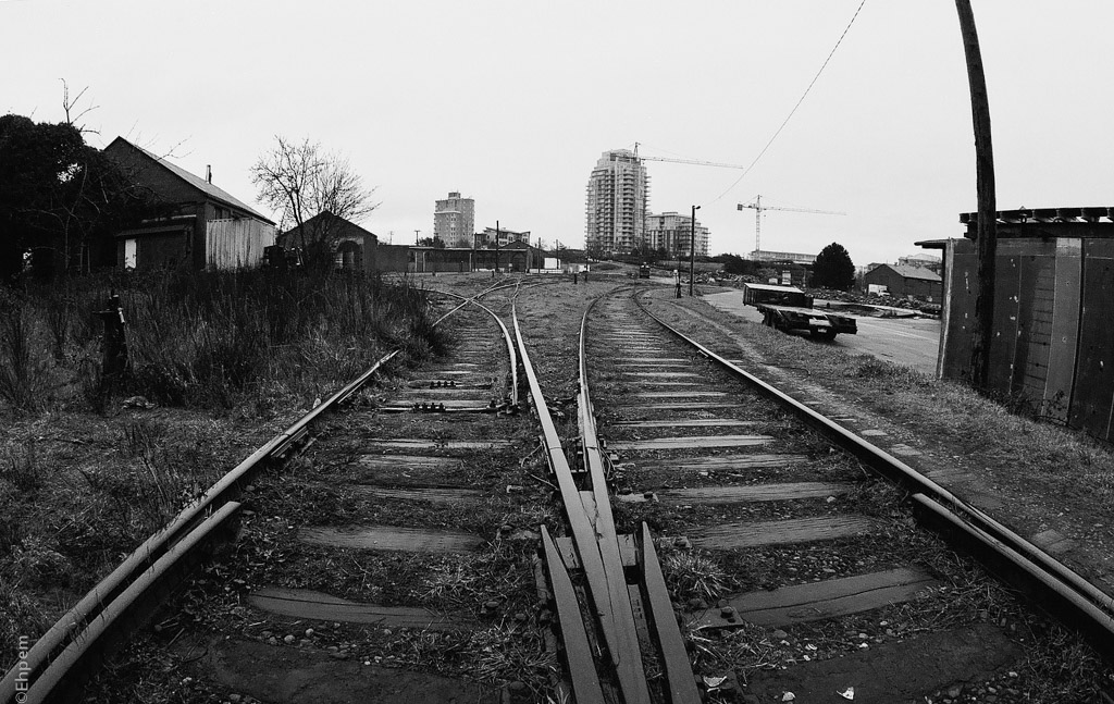
The E&N roundhouse (center left in distance) in Vic-West was a great place to try out this 1960’s fisheye lens.
I have posted another shot taken with this lens at the roundhouse (here)
It was raining and thus hard to keep drops off the front element for which no hood (or filter) is possible.
I am out of town for a few days and may not be responding to comments until I get back.
.
.
Canon Elan 7N, Takumar Fish-eye 17/4, Ilford XP2.
.


Nice! I love all the dark detail in the foreground. Hope you’re having a great time –
LikeLiked by 1 person
Thanks Lynn – I was presenting at a huge archaeology conference, something like 4,500 archaeologists, though only a few dozen saw my work. It was tiring, but interesting.
LikeLike
OK, now you’ve got me very curious – what is your specialty? And do you give much thought to links between that work and this work?
LikeLiked by 1 person
Hi Lynn. My specialty is kind of two things – I am an expert in heritage policy in BC because I worked for government for 20 years, but my heart is with coastal archaeology which I have been doing for more than 40 years (gasp) in BC (and in WA too, a long time ago). Current research that I am part of is focused on finding evidence for the first peopling of the Americas which probably occurred along the Pacific coast.
As to the connection with photography, it was my ability to use a camera (sort of) that got me on my first archaeology project all that time ago. I rarely blog about my archaeological work for a variety of reasons (results need analysis and peer reviewed publication, First Nations may not view publicity favourably, and so on). But, if you check out this link and then look at the the 3 or 4 subsequent posts you will get an idea of some of the work I do/have done. https://burntembers.com/2012/06/18/setting-up-kilgii-gwaay/
LikeLiked by 1 person
OK, feeling powerful envy now, after going through a number of your posts about the trip on the Passing Cloud, etc. Thank you for explaining, and for the link. When I google map some of the locations, it feels so good to see no roads and nothing but trees, and rocks…though I understand logging and mining have been problems in some locations – still, it feels good to read about the landscape and seascape up there. Maybe someday i will get there! Re the connection between archaeology and photography, especially with older film cameras, I’m thinking about more subtle connections, like underlying threads that may be more obscure, but connect the two interests for you.
LikeLiked by 1 person
It is a wonderful place, and much of it is unspoiled by industrial activity.
A cool thing on google maps is that they have some “street view” imagery in places. It is worth looking for some of it because you can then take a virtual boat ride, or hike a trail.
I haven’t thought much about subtle connections between archaeology and photography, but I should in case there is an untapped gold mine there – more than just the quest for understanding through compiling details into a longer view/big picture.
LikeLike
Nice one!
LikeLiked by 1 person
Thanks Kate!
LikeLiked by 1 person
It really is quite a photo….makes me want to write a story about where those tracks are headed.
LikeLiked by 2 people
Well, you should write the story. The tracks in front of the picture head into the roundhouse. Behind me they head north up Vancouver Island. Sadly, the distance they travel, and the condition of the railway has diminished very much the past few decades. repeated efforts to revitalise the route and make it into a commuter run have failed.
LikeLike
Perfect in monochrome. Terrific shot.
LikeLiked by 2 people
Thank you Jane. Good thing, because I only had black and white film for this lens, that day.
LikeLiked by 1 person