
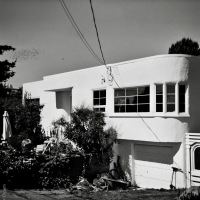
Gonzales Hill Observatory

Views of Gonzales Observatory surround me. I see it from my back yard, as I walk down the street, when I ride my bike the last mile or so home from work, from pretty well anywhere on Harling Point and many places in south Oak Bay. On a nice day, or when caught in sunlight, it draws the eye to the top of Gonzales Hill. The building is now within a park, but is still a functioning scientific laboratory, in use by the University of Victoria for atmospheric biogeochemistry research. Their website gives the following history:
“The Gonzales Observatory (GO) is part of the School of Earth and Ocean Sciences (SEOS) Biogeochemistry Facility at the University of Victoria. Situated on top of Gonzales Hill, around 4 km from UVic, the GO is one of the oldest buildings in Victoria. Originally the building was constructed for geophysical measurements, but was adapted by Denison for astronomic observation. As the ambient city light made this location less [suitable] for astronomy, it became the home of a[n] Atmospheric Environment Service weather station. The site boasts one of the longest climate measurement records on the west coast of North America. Today, at this location we conduct our research in atmospheric trace gases using remote sensing techniques. In particular, we pursue the development of Tunable Diode Laser Absorption Spectroscopy (TDLAS). This is an optically based approach to measure the spatial and temporal distribution of greenhouse gases in an urban environment.”

.
Reading that description of the atmospheric research makes me wonder if they can tell when we have the wood stove lit.

.
This heritage building is about 100 years old and encased in a small (2 ha), rocky, hilltop park.

.
It is accessed by foot from the end of Barkley Terrace on the south side, or via car from Denison Road, which you get to from the east end of Fairfield Road. If you want to walk in a loop, there is a staircase at the upper eastern end of Denison that goes all the way down to the eastern end of King George Terrace in McNeill Bay. I (and your knees) recommend taking the stairs down; there must be a hundred or more of them. Gonzales Hill has great views of southern Victoria, and indeed looks over most of my immediate surroundings.

.
.


Pingback: Observatory Test | burnt embers
I have lived in Victoria since 1971 and never seen the inside. How can I see it. Patrick Scaia.
LikeLike
Hi P Scaia – I am not sure I can help you. I have lived here longer than that and have never found an opportunity to get inside, even though I walk past the Observatory many times a year. I believe the building is fully tenanted – probably still in part by the U-Vic School of Earth and Ocean Sciences, and by The Land Conservancy. Perhaps if you contact one of those tenants someone would be kind enough to show you around the parts that they have access too.
LikeLike
Pingback: Band Photos at the Observatory | 52 rolls
Pingback: Railing with Shadow | burnt embers
Pingback: Constrained Observations | burnt embers
Pingback: Shadow of Pine | burnt embers
Pingback: Rail with “Dog” | burnt embers
Pingback: Railing with Shadow | burnt embers
Pingback: Observed Leap | burnt embers
Pingback: Cubism II | burnt embers
Pingback: Down | burnt embers
I came back ‘home’ from US after 6 yrs military service and was sent to Gonzales in April 66…leaving there in late 69 for Vancouver airport. Loved the place. Fantastic office to work in…and never tired of the view. In the ‘big snow’ winter of 68/69 I was the lone weekend observer and had to come up the hill from Ross Bay (as far as I could get my car even with snow tires) on skis… Saw no other traffic other than an old man (probably my age now!) on snowshoes heading for Fairfield Plaza… Arrived an hour late for the radio station calls. Hard too believe it’s so long ago.
LikeLike
Hi Jas – thank yous so much for commenting – its great to get some personal history and feeling of the place when it was in full use. I remember that snow, it was the year we moved from Edmonton to the coast and I was a kid. I did not think much of it, as I was used to long snows, but I do remember a lot of people being paralyzed by the depth of snow and that it lasted for two, or was it three, weeks. Nice to think that someone still went to work at the top of a hill, even if it took skis to get there. Thanks again, these comments add so much to my blog!
LikeLike
Brings back memories for me. I worked for the Canadian Meteorological Service and was first stationed at Gonzales when it was a full 24 hour observing and synoptic site with an on-duty forecaster during weekdays in 1967-1968. I returned in 1971 when Gonzales was a partial weather observing site with a M.A.R.S. automatic station(the first automatic weather station in Canada) and my main duty was Climatological data processing still done by hand in the 1970s — this ended in 1979 when the Climate Data Centre was relocated to Vancouver for access to a mainframe computer. In the 1980s there was only one staff member from Environment Canada during weekdays.
LikeLike
Hi Carl – thanks so much for commenting on this post. It is very interesting to hear from someone that worked there and to get this history of its use in the latter part of the 20th Century. It must have been a very nice place to work, with the great views. Though the building might not have been all that comfortable as an office.
LikeLike
Pingback: 200 King George Terrace « burnt embers
Pingback: Mountains over Victoria « burnt embers
The rock on the hill looks like sandstone. Is that what it is?
LikeLike
Douglas – I can say for sure that it is not sandstone. But what exactly it is, I don’t know. I’ll see if I can find a geological map on line somewhere. Or perhaps Branta will check back in, it’s the kind of thing she might know.
LikeLike
Pingback: Sunset Windows « burnt embers
I heard the TLC is using it as an office space.
LikeLike
Hi Branta – there were temporary TLC (The Land Conservancy) event signs last time I was up there. I expect there is more than enough room to accommodate them and the biogeochemists, after all, how many of those guys can there be? I bet they have to explain that tag at social gatherings, if they forget and let the full name slip. Probably they shorten it to chemist, or scientist, or something like that.
LikeLike
Definitely a Victoria landmark. Last time I climbed up there (not using stairs) was 20 years ago. Even then I did not realize UVIC still used it for anything serious. Let’s hope historic value is greater than the developers’ value. Not holding my breath, though. I can foresee a not too far of future where the old observatory becomes a high end apartment building, flanked by the kind of development that takes place along the seaside there. Good article and photo essay.
LikeLike
Hi Joseph. This was, and perhaps still is, a federal property, though I think it was transfered to local government control. The property used to be quite a bit larger, but in the Martin cut-back era a chunk of it was sold off, on the west slope, and is now covered in housing. I believe that this location is a formal Capital Regional District park. Also, the observatory is a registered heritage site as per a decision by the City of Victoria in the early 1980’s, so there are restrictions on what can be done to the building. As these things go, it seems a pretty securely protected location.
LikeLike
Thanks for the enlightenment and I hope you are right.
LikeLike
Joseph – I got curious about what exactly the park boundary looks like because I was a bit surprised to see a brand new house (on what I thought was park or someone’s rock garden) being built in the past few months. I looked at the CRD (Capital Regional District) “Natural Areas Atlas” which is a fantastic map resource for the entire CRD. It has very detailed satellite images, lot boundaries, 2m contour lines, natural history layers, bathymetric data and all kinds of other information. The map interface is not wonderfully intuitive, but with a bit of poking around its not too hard to get the hang of it. You need to start with the very small “layers” tab in the upper right corner of the map, and work from there.
Anyway, the satellite image with lot boundaries laid over it shows that there are 8 vacant lots immediately adjoining (4), or within one house (4) of the park. Of these one is now under construction immediately adjacent to the stairs up from Barkley Terrace. So, while the Gonzales Observatory property and building are protected and likely to survive for a long time to come, the ambience or aesthetic of this location will become less natural and private and come to feel more cramped. This may take some time as many of these vacant lots are probably owned by adjacent lot holders who value the undeveloped space, and probably can afford to keep them that way. One of the lots has no apparent street access, so may be unbuildable as well. It is inevitable that there will be further changes in this area. Hopefully they will not affect the pleasure of visiting too much.
LikeLike